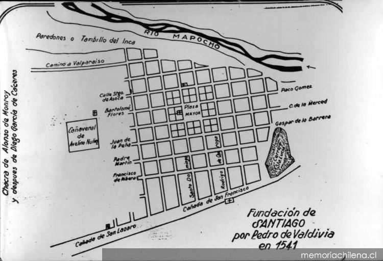
The map that outlined the first streets of the capital of Chile remains practically intact since its foundation, in February of 1541. According to ancient chroniclers, The plan covered ten streets from east to west and eight more from north to south: from the Santa Lucía hill to the current Teatinos street, and from the Mapocho River to what is now Bernardo O'Higgins Avenue.
The original design maintained the urban planning regime of the rest of the cities that the Spanish empire established in America, taking as a background the work of the Catalan friar Francesc Eiximenis (1327-1409), who proposed an ideal of a city with a large central square, divided into four neighborhoods or districts, each with a minor plaza and a mendicant convent, an idea of a modern city for America.
“The founding plan of Santiago is the son of the Black Death, the worst plague that Europe knew in the Middle Ages and where half of Europeans died. That is when this Franciscan friar begins a new phase of the Catholic Church, with a concern for the quality of life and for the poorest. The streets proposed are wider and straighter, where the good air can cross and among the sun, where it can be cleaned more easily”, explained to I love Santiago the writer and researcher Miguel Laborde.
Original brought
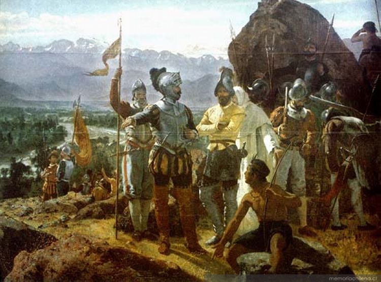
The territory chosen by the Spanish Pedro de Valdivia to found the city he originally called Santiago de Nueva Extremadura It was part of the Inca empire of Tawantinsuyu, that had arrived a century earlier to “Chilean” lands.
After breaking camp on Thopahue Hill (today San Cristobal) was carried out first parliament with indigenous leaders, to whom Valdivia announces the taking possession of these lands in the name of the King of Spain. According to the chronicles, The majority of the regional chiefs of the Santiago basin attend the meeting: Product Product, Huelen Huara, Apoquindo, Vitacura and the Inca curacas Quilicanta and Incarongo, among others.
In the date, The chief of Maipo Millacura advises founding the city next to the Huelén hill. Taking the suggestion, later the conquerors They perform the ceremony that founded the city by nailing a cross in what is now the Plaza de Armas, from where a square like a chess board was drawn with string, with 80 a 90 apples of 138 Castilian rods of length each, separated into streets 12 powers.
The heart of the city
Main square, call Main Square because the soldiers would camp there, was established as kilometer zero of the new city. Although the place had a spiritual meaning according to the friar Eiximenis, Some medieval traditions such as hanging were maintained there., which was used for the first time in August 1541 to execute six Spaniards accused of conspiring against Valdivia. A street market was also located until the 18th century.
In its surroundings, the blocks were divided into four plots distributed among institutions and conquerors. The religious power occupied the west side, considered the most important, site of the current Metropolitan Cathedral. While On the north side the civil power was located.
The first names
There are no official street names., but it is popularly given a name referring to the characters who live there or the most important citizens.. The lots around the Plaza de Armas were distributed among those near Valdivia, among them Diego García Cáceres, Pedro Gomez, Pedro Miranda, Francisco de Aguirre, Antonio de Pastrana and Alonso de Escobar. No women were part of this distribution.
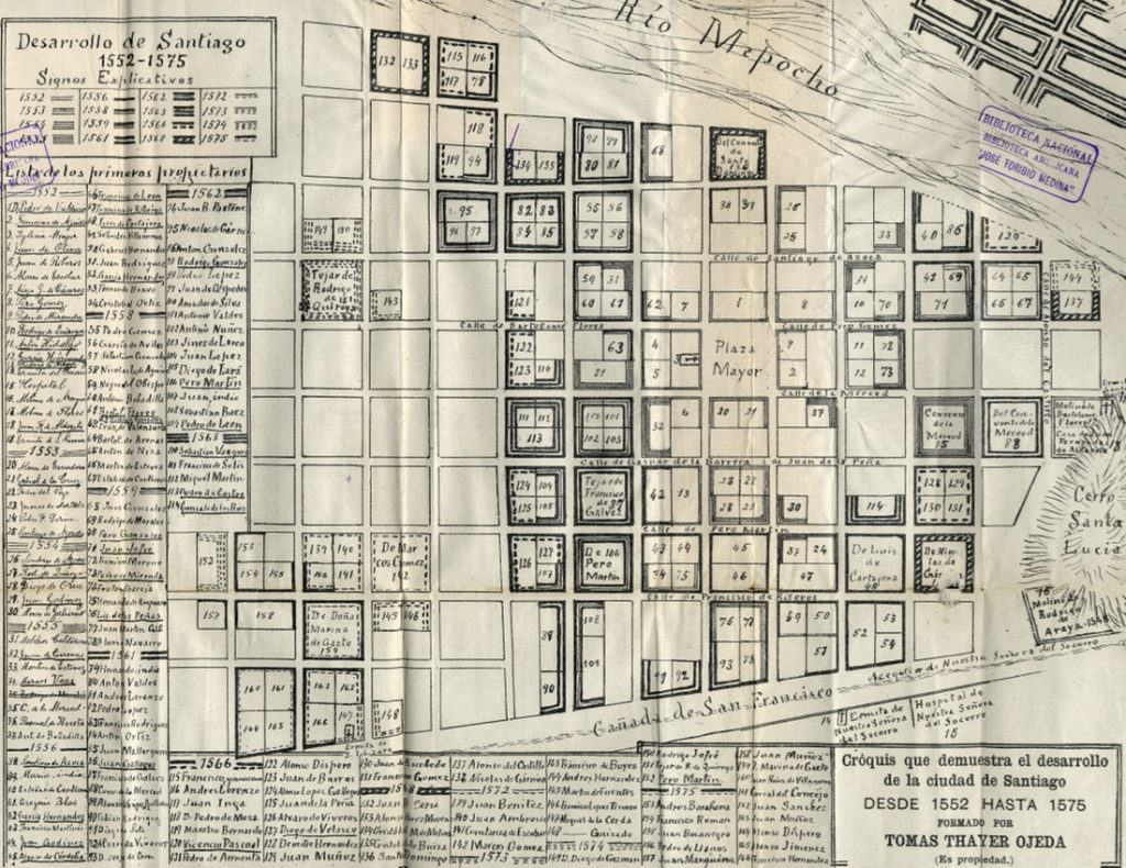
When comparing Thayer Ojeda's plan and the current map of the capital center we find:
- Santiago de Asoca / Today Santo Domingo street
- Bartolome Flores / Today Cathedral Street
- Paco Gomez / Today Monjitas Street
- La Merced Company / Today Compañía and Merced streets (separated by the Plaza de Armas)
- Juan de Peña and Gaspar de la Barrera / Today Orfanos Street
- Father Martin / Today Agustinas Street
- Francisco de Riberas / Today Moneda Street
- San Francisco Canyon / Today Alameda Bernardo O'Higgins Avenue
- Santo Domingo / Today Ahumada Street
- Chief Constable / Today State Street
- Rodrigo de Quiroga / Today San Antonio street
Its surroundings
In Santiago, It is checkerboard layout -military criteria that predominated in the design of the city- It adapted to the territory with a curve that recognizes both the edge of Mapocho and the Santa Lucía hill.. As Laborde described, Spanish soldiers arrived at this place at dusk to relax., while on the hill the town priest evangelized the indigenous children.
In this nascent city there were no bridges, hence Santiago was divided from the Dig in in the months when the flow of the Mapocho increased. Across the river, “The street layout was more irregular and disorderly, the indigenous people lived there, the mestizos and the poorest Spaniards. Fights between young people from Santiago and the chimberos were common.”, added Laborde. Just with the construction of the Tajamares (or brick walls) At the end of the Colony both territories would be united.
La Chimba and Recoleta
— Apu Andes (@ApuAndeschile) June 6, 2021
Pre-Hispanic period, The extensive territory located north of the Mapocho River was known as Chimba, that is to say, "de la otra orilla" in Quechua language. Since the Spanish conquest, It was used to establish precarious settlements of Indians and mestizos. pic.twitter.com/sYZSVCBXpu
“The shore of the Mapocho reached almost San Pablo Street. When the Tajamar was built, The coastal walk went through the current sector of Ismael Valdés Vergara and Mapocho (Balmaceda). The first arch or "eye" of the Cal y Canto Bridge was dry, without water passage, and a street with modest houses was born that was called Calle del Ojo Seco, later renamed Sama and, at the moment, General Mackenna”, Criss Salazar concluded.
A) Yes, the dynamite that paved the way to extend the city to the east and the canalization of the Mapocho River were the two great transformations of the original layout of the historic center. The rest of the street grid remains practically intact today..